
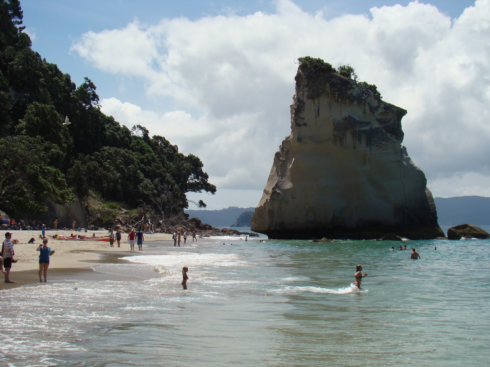
New Zealand has had an unusually wet and windy summer. However, after New Year, the weather seemed to improve, and we (Andrew, Maria and Katka) headed north, towards Cape Reinga. On the way, following Lonely Planet advice, we headed for
Abbey Caves near Whangarei in search of glowworms. The caves are in limestone country, a short
walk from the road, and completely uncommercialised. The first, Organ Cave,
seemed to be a big hole in the ground that would be difficult to enter, and we
passed it by. The second (Middle Cave) was easy to scramble into, and after
some searching, we spotted a few tiny lights. Then to the last, Ivy Cave, also
easy to enter, but no sign of life. On the way back we passed a group with wet
trousers; they had been into the first cave, and reported that there were plenty of glowworms, but to see them involved wading through water; so we went back to
it, climbed down over steep rocks, took off boots, and entered the water. It
was less than knee-deep, and after 10 metres or so we were in a high chamber.
Looking up was literally (no exaggeration) like gazing at the night sky - a band
of thousands of pinpoints of light; the Milky Way. One transferred to the tip
of my finger: it was no more than a few mm long. According to Wikipedia, likely to be Arachnocampa species; the larvae let out
'snare lines' that trap midges etc. attracted by the light.
 Kawakawa, just south of the Bay of Islands, is a small town with a preserved
railway (we had coffee at the station cafe), but the reason most people go
there is to visit the toilets, designed by Austrian artist Friedensreich Hundertwasser
who lived nearby. Shades of Gaudi, with irregular shaped coloured tiles, glass
bottles in walls, and organic curves. The ice ceam parlour opposite doubles up
as a ceramic homage to Hundertwasser.
Kawakawa, just south of the Bay of Islands, is a small town with a preserved
railway (we had coffee at the station cafe), but the reason most people go
there is to visit the toilets, designed by Austrian artist Friedensreich Hundertwasser
who lived nearby. Shades of Gaudi, with irregular shaped coloured tiles, glass
bottles in walls, and organic curves. The ice ceam parlour opposite doubles up
as a ceramic homage to Hundertwasser.
 We stayed at Bay of Islands Cottages, near the historic town of Russell. Highly recommended for good company, lovely setting, and fabulous breakfasts. This was the base for our day trip to Cape Reinga, at the northernmost tip of North Island, a sacred place for the Maoris. It is where the Tasman Sea (between Australia and New Zealand) and the Pacific Ocean meet, and it can be a violent meeting.
Returning to Bay of Islands, we stopped at the world-famous (really) Mangonui Fish Shop, perched over the harbour. Best fish and chips since Whitby two years ago.

There is a Maori boat (dug-out from a giant Kauri tree of course) made to celebrate 150 years of the treaty,

and a Marae (meeting house) made in the 1930s for the centenary. The Residency (home of James Busby who before 1840 worked to unite the northern tribes and encouraged the signing of the treaty) is now an interesting museum.

We returned to Auckland down the west coast route through the Waipua kauri forest, with some of the biggest surviving kauri trees, notably Tane Mahuta, 51 m high, 13.8 m in girth, over 1000 years old. Almost all the kauris were felled for timber; they have straight trunks with no knots and the wood was prized for building, and for ships' masts. The trees also produce a gum, which solidifies (especially if buried for hundreds of years) and is like amber. The gum had industrial uses too. All in all, the kauri industry was the main livelihood for many early European immigrants here. At the next stop, for a walk to the 'four sisters' and other big kauris, the rain started - appropriately for a rain forest.

On our return to Auckland, we made day trips. To the north-west of Auckland, Kumeo is where the wine industry in New Zealand was started, by Croatian immigrants. After tasting and buying wine at one of the original family vineyards, we continued to Muriwai Beach, on the west coast. Here there is a famous gannet colony - an overspill from a nearby island, still expanding. There are also graceful terns, apparently the original occupants before being displaced by the gannets.


Friday January 13. Rangitoto, the volcanic island just offshore from Auckland, was created only about 600 years ago. We (Maria and Andrew) took the ferry and walked to the summit, past fields of volcanic rock virtually bare of vegetation (though if you look closely you see lichens,
mosses etc.) mixed with dense woodland, with an enormous variety of plants,
from small ferns to tree ferns, flowering plants, bushes, pohutekawa ,manuka
and other trees (some hundreds of years old), epiphytes. The crater is now completely covered with bush (NZ for forest). Back at the shore, waiting for the ferry, we watched pukekos (water birds) among the rock pools and mangroves.
For more photos, follow this link:https://plus.google.com/photos/113683827814024608633/albums/5699219091499197761?authkey=CIGj8brllbzs2wE
The ferry leaves from the new terminal beside the splendid old Ferry Building, now overshadowed by the skyscrapers of the CBD (central business district).
Supposedly Waiheke has a special climate; it's famous for wine, and olives - and sandy beaches. When we were there it rained. But we visited one vineyard, the first on the island, Goldie's, founded by the Goldwaters, who have recently given it to the University of Auckland.
Next, we headed south, to the middle of North Island

Tongariro, just south of Lake Taupo, was NZ's first National Park, created by a gift of Maori lands to the nation by the paramount chief in the late 19th century. In the winter it is a centre for skiing; in the summer, hikers enjoy the dramatic volcanic terrain. We were there to do the Tongariro Alpine Crossing, a 19.4 km hike, supposedly one of the top 10 one-day hikes in the world. Apparently, at least 65,000 people do the crossing each season, on average 800 per day.
 And then, magically, the mist cleared and we saw below us the Emerald Lakes, complete with fumaroles (steam seeping out from hot underground rocks). We lingered here, it was so beautiful, and such a contrast to what we had been through.
Across the Central Crater, a flat expanse with scattered lumps of lava, to the Blue Lake, bigger than the Emerald Lakes but less of a surprise.
